|
|
click photo for larger file

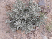
Atriplex acanthocarpa var. acanthocarpa
Tubercled Saltbush
|
Photographer: E. Wynn Anderson
ID: 0000 0000 0815 0083 (2015-08-02)Copyright © 2015 Wynn Anderson
|
|
INFORMATION PROVIDED WITH THE PHOTO
|
date of photo Feb 7, 2015
latitude 29.25238 longitude 103.53186
View on Google Maps.
location
OLd Maverick Road, 3.8 miles south of TX 118 to Panther Junction, near Rattlesnake Mt. campsite, Big Bend National Park (Brewster County, Texas, US)family
Amaranthaceae
plant community Chihuahuan Desert scrub at 2569'notes foliage aspect, plant on creosote flats of gravelly volcanic alluviumkeywords: CDR, Chihuahuan Desert, Big Bend
contributor's ID # CDR/BB 1176 photo category: Plant - shrub
|
MORE INFORMATION ABOUT THIS PLANT
|
| common names
Tubercled Saltbush, Burscale (photographer)
View all photos in CalPhotos of Atriplex acanthocarpa var. acanthocarpa Check Google Images for Atriplex acanthocarpa var. acanthocarpa |
|
The photographer's identification Atriplex acanthocarpa var. acanthocarpa has not been reviewed. Click here to review or comment on the identification. |
|
Using this photo The thumbnail photo (128x192 pixels) on this page may be freely used for personal or academic purposes without prior permission under the Fair Use provisions of US copyright law as long as the photo is clearly credited with © 2015 Wynn Anderson.
For other uses, or if you have questions, contact E. Wynn Anderson wanderson@UTEP.edu. |
|
|
