|
|
click photo for larger file

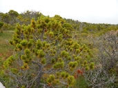
Pinus contorta ssp. contorta
Shorepine
|
Photographer: E. Wynn Anderson
ID: 0000 0000 0714 1351 (2014-07-22)Copyright © 2014 Wynn Anderson
|
|
INFORMATION PROVIDED WITH THE PHOTO
|
date of photo Jun 24, 2014
latitude 49.01350 longitude 125.65510
View on Google Maps.
location
Shorepine Bog Trail, off Wick Road to Kwisitis Visitor Center, Pacific Rim National Park Reserve, (Vancouver Island, British Columbia, Canada)family
Pinaceae
plant community Sphagnum bog community in coastal temperate rainforest at 21 m (70') elev.notes dwarfed Pinus contortus specimen on hummocks at margins of large open acidic wetland bogkeywords: CAN
contributor's ID # CAN 1668 photo category: Plant - tree
|
MORE INFORMATION ABOUT THIS PLANT
|
| common names
Shorepine (photographer)
View all photos in CalPhotos of Pinus contorta ssp. contorta Check Google Images for Pinus contorta ssp. contorta |
|
The photographer's identification Pinus contorta ssp. contorta has not been reviewed. Click here to review or comment on the identification. |
|
Using this photo The thumbnail photo (128x192 pixels) on this page may be freely used for personal or academic purposes without prior permission under the Fair Use provisions of US copyright law as long as the photo is clearly credited with © 2014 Wynn Anderson.
For other uses, or if you have questions, contact E. Wynn Anderson wanderson@UTEP.edu. |
|
|
