|
|
click photo for larger file

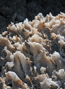
Detail of Death Valley Salt Pan at Devil's Golf Course
|
Photographer: Ron Wolf
ID: 0000 0000 0612 1274 (2012-06-20)Copyright © 2012 Ron Wolf
|
|
INFORMATION PROVIDED WITH THE PHOTO
|
date of photo Mar 14, 2012
location
Death Valley National Park (Inyo County, California, US)notes The salt pan at Devil's Golf Course near the center of Death Valley is not as low as the salt pan at Badwater Basin and less often subjected to the leveling effect of temporary flooding. The pan develops a rough, blocky structure when the mud beneath the surface layer of salt dries, contracts and cracks. New deposition within the cracks pushes the polygonal blocks of salt upward and outward. New salt crystals grow within the cracks and at the margins of the blocks, often producing these small, intricate structures. The salt is primarily sodium chloride but also contains carbonates, sufates and borates of sodium and calcium.keywords: Geology, Earth Science, dry lake, deposition, geomorphology, crystal, evaporites
camera Canon EOS 7D, 52mm, f/16, 1/100 sec.
photo category: Misc. - geology
|
| |
|
Using this photo The thumbnail photo (128x192 pixels) on this page may be freely used for personal or academic purposes without prior permission under the Fair Use provisions of US copyright law as long as the photo is clearly credited with © 2012 Ron Wolf.
For other uses, or if you have questions, contact Ron Wolf RonWolf[AT]EyeOnNature.com. (Replace the [AT] with the @ symbol before sending an email.) |
|
|
