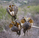
INFORMATION PROVIDED WITH THE PHOTO
|
date of photo Feb 2006
latitude 34.43102 longitude -119.87712 max error distance 13661 meters
View on Google Maps.
horizontal datum World Geodetic System 1984 georeferencing source GeoLocatelocation
East from Santa Barbara (Santa Barbara County, California, US)family
Agavaceae
order
Asparagales
class Liliopsida
synonyms Yucca whipplei
plant community Rocky hillsidephoto category: Plant - annual/perennial
|
ADDITIONAL TAXONOMIC NOTES FOR THIS PHOTO
|
| name change notes May 21, 2014: TJM1 name Yucca whipplei changed to TJM2 name Hesperoyucca whipplei . (University & Jepson Herbaria) |
MORE INFORMATION ABOUT THIS PLANT
|
| common names
Chaparral Yucca (photographer)
Look for Jepson Manual treatments, maps (University & Jepson Herbaria)View Calflora record for Hesperoyucca whippleiView all photos in CalPhotos of Hesperoyucca whipplei Check Google Images for Hesperoyucca whipplei |
