|
|
click photo for larger file

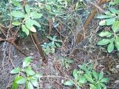
Arbutus menziesii
Pacific Madrone
|
Photographer: Scott Jones
ID: 0000 0000 0313 1350 (2013-03-10)Copyright © 2013 Scott Jones
|
|
INFORMATION PROVIDED WITH THE PHOTO
|
date of photo Jan 5, 2013
latitude 33.23755 longitude -116.90316 max error distance 784 meters
View on Google Maps.
horizontal datum World Geodetic System 1984 georeferencing source GeoLocatelocation
North side of Rodriguez Mtn. (San Diego County, California, US)family
Ericaceae
notes Below the middle 'V' of the magnificent Rodriguez Mtn. escarpment, at the base of the escarpment cliffs. Approach was from Hell Hole Canyon Preserve. Photo showing three burl sprouts(one barely noticeable behind twiggery) of a few years old. About eight burl-sprouting clumps(due to fire in 2007) of Madrone are in this population patch, about 8 to 10 feet tall from ground level, with multiple shoots per burl. There is no trail to get here, it's a very gnarly access.photo category: Plant - tree
|
MORE INFORMATION ABOUT THIS PLANT
|
| common names
Pacific Madrone (photographer)
Look for Jepson Manual treatments, maps (University & Jepson Herbaria)View Calflora record for Arbutus menziesiiView all photos in CalPhotos of Arbutus menziesii Check Google Images for Arbutus menziesii |
|
The photographer's identification Arbutus menziesii has not been reviewed. Sign in to review or comment on this photo |
|
Using this photo This photo is in the public domain and may be freely used for any purpose. Please credit the photographer Scott Jones.
If you have questions, contact Scott Jones scnatives[AT]att.net. |
|
|
