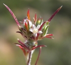
INFORMATION PROVIDED WITH THE PHOTO
|
date of photo Jun 29, 2011
latitude 35.44837 longitude -118.38477 max error distance 1671 meters
View on Google Maps.
horizontal datum World Geodetic System 1984 georeferencing source GeoLocatelocation
Southern Sierra Nevada, Piute Mountain area (Kern County, California, US)family
Polemoniaceae
synonyms Eriastrum tracyi
plant community Openings in California juniper woodlandnotes The identification of the plant in this photo was recently changed by Cal Photos to E. brandegeeae in error. E. brandegeeae is NOT a synonym of E. tracyi as indicated by Cal Photos. The plants in these photos are backed up by vouchers and the identification has been confirmed by experts.photo category: Plant - annual/perennial
|
ADDITIONAL TAXONOMIC NOTES FOR THIS PHOTO
|
| name change notes May 21 2014: ICPN update via script. synonym: Eriastrum tracyi; accepted name: Eriastrum brandegeeae |
MORE INFORMATION ABOUT THIS PLANT
|
| common names
Tracy's Eriastrum (photographer)
Look for Jepson Manual treatments, maps (University & Jepson Herbaria)View Calflora record for Eriastrum tracyiView all photos in CalPhotos of Eriastrum tracyi Check Google Images for Eriastrum tracyi |
