|
|
click photo for larger file

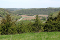
Allamakee County, Iowa - State Highway 76 and County Road A26
|
Photographer: Jeff Abbas
ID: 0000 0000 0810 1375 (2010-08-18)Copyright © 2010 Jeff Abbas
|
|
INFORMATION PROVIDED WITH THE PHOTO
|
date of photo May 12, 2010
location
Allamakee County, Iowa - confluence of the Upper Iowa River, Bear Creek and Waterloo Creek (Allamakee County, Iowa, US)notes This is a view of the location where the majority of my wildflower photos have been taken. The photo was taken from the top of the hill just north of our farm on Bear Creek Drive. The Upper Iowa River, Waterloo Creek and Bear Creek all meet here. There are remnants of different habitats within 'spittin' distance' of our home. Goat prairies, oak savannas and riparian habitats are filled with Tallgrass Prairie flora blooming from mid-March through early October. In many of my photo locations here on CalFlora, I note 'Bear Creek Drive at Highway 76'. That exact location at the base of the hill from which I took this photo and not visible here. The intersection that is visible in this photo is State Highway 76 and County Road A26, 3/4 mile south of Bear Creek Drive.camera Canon PowerShot SX10 IS, wide angle, manual settings
contributor's ID # allamakee_county_iowa_habitat_001 photo category: Landscape - habitat
|
| |
|
Using this photo The thumbnail photo (128x192 pixels) on this page may be freely used for personal or academic purposes without prior permission under the Fair Use provisions of US copyright law as long as the photo is clearly credited with © 2010 Jeff Abbas.
For other uses, or if you have questions, contact Jeff Abbas chefjeff[AT]acrec.com. (Replace the [AT] with the @ symbol before sending an email.) |
|
|
