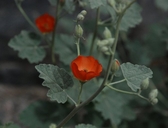
INFORMATION PROVIDED WITH THE PHOTO
|
date of photo Mar 24, 2010
latitude 36.83061 longitude -117.10710 max error distance 6521 meters
View on Google Maps.
horizontal datum World Geodetic System 1984 georeferencing source GeoLocatelocation
Titus Canyon, Death Valley National Park (Inyo County, California, US)family
Malvaceae
synonyms Sphaeralcea ambigua ssp. ambigua
photo category: Plant - annual/perennial
|
ADDITIONAL TAXONOMIC NOTES FOR THIS PHOTO
|
| name change notes May 21 2014: ICPN update via script. synonym: Sphaeralcea ambigua ssp. ambigua; accepted name: Sphaeralcea ambigua var. ambigua |
MORE INFORMATION ABOUT THIS PLANT
|
| common names
Mountain Apricot Mallow (photographer)
Look for Jepson Manual treatments, maps (University & Jepson Herbaria)View Calflora record for Sphaeralcea ambigua var. ambiguaView all photos in CalPhotos of Sphaeralcea ambigua var. ambigua Check Google Images for Sphaeralcea ambigua var. ambigua |
