|
|
click photo for larger file

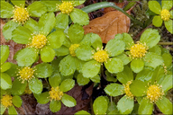
Sanicula epipactis
Hacquetia
|
Photographer: Dr. Amadej Trnkoczy
ID: 0000 0000 0407 0064 (2007-04-02)Copyright © 2007 Dr. Amadej Trnkoczy
|
|
INFORMATION PROVIDED WITH THE PHOTO
|
date of photo Mar 30, 2007
latitude 46.20415 longitude 13.65890
View on Google Maps.
location
Mixed woods on the right bank of river Soca, between villages Kamno and Volarje, altitude 200 m (650 feet), border between submediterranean and alpine phytogeographical region of East Julian Alps (Posocje, Slovenia)synonyms Hacquetia epipactis
notes Slo.: tevjecamera Nikon D70 / Nikorr Micro 105mm/f2.8 / Film: N/A
photo category: Plant - annual/perennial
|
ADDITIONAL TAXONOMIC NOTES FOR THIS PHOTO
|
| name change notes Feb 19 2025: Plants of the World (POTW) update via script. Previous name: Hacquetia epipactis ; updated name: Sanicula epipactis |
MORE INFORMATION ABOUT THIS PLANT
|
| common names
Hacquetia (photographer)
View all photos in CalPhotos of Sanicula epipactis Check Google Images for Sanicula epipactis |
|
The photographer's identification Sanicula epipactis has not been reviewed. Sign in to review or comment on this photo |
|
Using this photo The thumbnail photo (128x192 pixels) on this page may be freely used for personal or academic purposes without prior permission under the Fair Use provisions of US copyright law as long as the photo is clearly credited with © 2007 Dr. Amadej Trnkoczy.
For other uses, or if you have questions, contact Dr. Amadej Trnkoczy amadej.trnkoczy[AT]siol.net. (Replace the [AT] with the @ symbol before sending an email.) |
|
|
