|
|
click photo for larger file

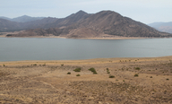
View from Sierra Way towards Cook Peak and Lake Isabella.
|
Photographer: Joyce Gross
Collection: VTM
ID: 1111 1111 2222 2684 (2015-04-28)Copyright © 2015 Joyce Gross
|
Related images:
retake:


|
|
INFORMATION PROVIDED WITH THE PHOTO
|
date of photo Apr 21, 2015
latitude 35.68598 longitude -118.42728
View on Google Maps.
location
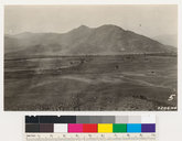
along Sierra Way, 7.7 km south of Kernville (Kern County, California, US)notes This is a retake of an image taken in 1927 before the Kern River was dammed and Isabella Lake created. This image shows Isabella Lake with Cook's Peak in the background, to the south. The original image is part of the Wieslander Vegetation Type Map (VTM) collection. View information about the original image here. In 2015, the lake level is very low due to the drought.camera Canon 5DIII; 24-105mm lens
photo category: Landscape - habitat
original filename: VTM_220646_20150421_02_1000.jpg
|
| |
|
Using this photo This photo is in the public domain and may be freely used for any purpose. Please credit the photographer Joyce Gross.
If you have questions, contact Joyce Gross joyceg_NO_SPAM@berkeley.edu. |
|
|


