|
|
click photo for larger file

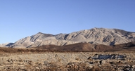
Basalt Flows / Death Valley National Park
|
Photographer: Ron Wolf
ID: 0000 0000 0214 0473 (2014-02-06)Copyright © 2014 Ron Wolf
|
|
INFORMATION PROVIDED WITH THE PHOTO
|
date of photo Nov 26, 2012
location
Along Hwy 190 near Towne Pass. Death Valley National Park (Inyo County, California, US)notes The dark rocks in the near and middle distance are olivine basalt. These flows, formed during the late Pliocene about 4 million years ago, emerged from many feeder vents and covered hundreds of square miles. They are well exposed along the flanks of the Argus Range and the Panamint Range. This flow on the west side of the Panamints extends from Towne Pass toward the south and west into Panamint Valley in the area traversed by Hwy 190. The layered rocks in the distance are Paleozoic sediments about 300-600 million years displayed here on the western side of the Cottonwood Mountains.keywords: geology, earth science, volcanism
camera Canon EOS 7D, 30mm, f/20, 1/320 sec.
photo category: Misc. - geology
|
| |
|
Using this photo The thumbnail photo (128x192 pixels) on this page may be freely used for personal or academic purposes without prior permission under the Fair Use provisions of US copyright law as long as the photo is clearly credited with © 2014 Ron Wolf.
For other uses, or if you have questions, contact Ron Wolf RonWolf[AT]EyeOnNature.com. (Replace the [AT] with the @ symbol before sending an email.) |
|
|
