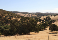
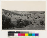
click photo for larger file

.7 miles south of Drytown along Hwy 49 (California)
|
Photographer: Joyce Gross
Collection: VTM
ID: 1111 1111 2222 2617 (2013-12-14)Copyright © 2013 Joyce Gross
|
Related image:
retake:

|
|
INFORMATION PROVIDED WITH THE PHOTO
|
date of photo Sep 20, 2013
latitude 38.43172 longitude -120.85263
View on Google Maps.
horizontal datum World Geodetic System 1984 georeferencing source GPSlocation
.7 miles south of Drytown along Hwy 49 (Amador County, California, US)notes This is a retake of a photo taken by Albert Everett Wieslander 73 years ago as part of the Wieslander Vegetation Type Analysis. See http://dpg.lib.berkeley.edu/webdb/vtm/search?mapno=&photono=2175&item=1&pageno=1 for more information about the original photo.camera Canon 7D; 15-85mm lens
photo category: Landscape - habitat
original filename: vtm_quad68_photonum2175_view3_20130920_11_ADJUSTED_1000px.jpg
|
|
|
|
Using this photo This photo is in the public domain and may be freely used for any purpose. Please credit the photographer Joyce Gross.
If you have questions, contact Joyce Gross joyceg_NO_SPAM@berkeley.edu. |
|

