|
|
click photo for larger file

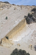
Clastic Dikes in the Bishop Tuff
|
Photographer: Ron Wolf
ID: 0000 0000 1012 1333 (2012-10-20)Copyright © 2012 Ron Wolf
|
|
INFORMATION PROVIDED WITH THE PHOTO
|
date of photo Oct 5, 2012
location
Near Sherwin Summit. North of Bishop (Mono County, California, US)notes The Bishop Tuff was formed 760,000 years ago from ash and pyroclastic flows from a huge volcanic eruption at Long Valley. This area was subjected to glaciation about 50,000 to 100,000 years ago. The crest of the hill is covered with a thin layer of gravel from this Tahoe Stage glaciation. The clastic dikes, the vertical structures seen here, were formed when the Tahoe Stage gravel filled extension fractures in the tuff. The glacial material is more resistant that the surrounding tuff and the dikes have become more prominent as the tuff has eroded. The dikes are exposed at a roadcut along US 395 about 10 miles north of Bishop.keywords: geology, earth science, geomorphology, volcanism, glacier, glaciation, Pleistocene, erosion, eruption
camera Canon EOS 7D, 47 mm, f/11, 1/500 sec.
photo category: Misc. - geology
|
| |
|
Using this photo The thumbnail photo (128x192 pixels) on this page may be freely used for personal or academic purposes without prior permission under the Fair Use provisions of US copyright law as long as the photo is clearly credited with © 2012 Ron Wolf.
For other uses, or if you have questions, contact Ron Wolf RonWolf[AT]EyeOnNature.com. (Replace the [AT] with the @ symbol before sending an email.) |
|
|
