|
|
click photo for larger file

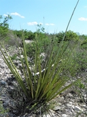
Hesperaloe funifera
Samandogue
|
Photographer: E. Wynn Anderson
ID: 0000 0000 1217 1631 (2017-12-22)Copyright © 2017 Wynn Anderson
|
|
INFORMATION PROVIDED WITH THE PHOTO
|
date of photo Jul 13, 2013
latitude 28.07960 longitude 101.08110
View on Google Maps.
location
Federal Highway MX 57(cuota) km 20, 12.4 miles northeast of Nueva Rosita, 19.7 miles southwest of junction with MX 57 (libre) near Allende (Mcp. Sabrinas, Coahuila, Mexico)family
Asparagaceae
plant community transition to Tamaulipan calcareous shrubland at 1542' (470mnotes plants in shallow calcareous soils and gravels on low hillside slope of white blocky Cretaceous limestone. Site represents an extreme eastern outlier of Chihuahuan Desert flora (Agave lechuguilla present) in transition to upland Tamaulipan brushland of Rio Grande plains.keywords: CDR, Chihuahuan Desert
contributor's ID # CDR 722 photo category: Plant - shrub
|
MORE INFORMATION ABOUT THIS PLANT
|
| common names
Samandogue, Giant Herperaloe (photographer)
View all photos in CalPhotos of Hesperaloe funifera Check Google Images for Hesperaloe funifera |
|
The photographer's identification Hesperaloe funifera has not been reviewed. Sign in to review or comment on this photo |
|
Using this photo The thumbnail photo (128x192 pixels) on this page may be freely used for personal or academic purposes without prior permission under the Fair Use provisions of US copyright law as long as the photo is clearly credited with © 2017 Wynn Anderson.
For other uses, or if you have questions, contact E. Wynn Anderson wanderson@UTEP.edu. |
|
|
