|
|
click photo for larger file

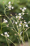
Kernera saxatilis
Kugelschoetchen (d)
|
Photographer: Dr. Amadej Trnkoczy
ID: 0000 0000 1210 1288 (2010-12-18)Copyright © 2010 Dr. Amadej Trnkoczy
|
|
INFORMATION PROVIDED WITH THE PHOTO
|
date of photo May 27, 2010
latitude 46.31064 longitude 13.46211
View on Google Maps.
location
Uèja valley, left bank of river Uèja, at the base of Globoški potok stream waterfalls, East Julian Alps (Posoèje, Slovenia)notes Slo.: kernerjevka - Habitat: Coarse scree and rocks, rock crevices, south oriented steep mountain slope, calcareous rock, dry ground but very humid air, moderately sunny place in a narrow valley, exposed to direct rain, average precipitations ~ 3.000 mm/year, average temperature 8-10 deg C, elevation 500 m (1.650 feet), alpine phytogeographical region. - Substratum: soil deposited in rock cracks. - Ref.: (1) Rothmaler 3, Exkursionsflora von Deutschland, 11.Augl., Elsevier, Spectrum (2007), p 639. (3) A.Martinèi et all., Mala Flora Slovenije, Tehnièna Založba Slovenije (2007), p 444.camera Canon G11, 6.1-30mm/f2.8-4.5
contributor's ID # Bot_424/2010_IMG0239 photo category: Plant - annual/perennial
|
MORE INFORMATION ABOUT THIS PLANT
|
| common names
Kugelschoetchen (d) (photographer)
View all photos in CalPhotos of Kernera saxatilis Check Google Images for Kernera saxatilis |
|
The photographer's identification Kernera saxatilis has not been reviewed. Sign in to review or comment on this photo |
|
Using this photo The thumbnail photo (128x192 pixels) on this page may be freely used for personal or academic purposes without prior permission under the Fair Use provisions of US copyright law as long as the photo is clearly credited with © 2010 Dr. Amadej Trnkoczy.
For other uses, or if you have questions, contact Dr. Amadej Trnkoczy amadej.trnkoczy[AT]siol.net. (Replace the [AT] with the @ symbol before sending an email.) |
|
|
